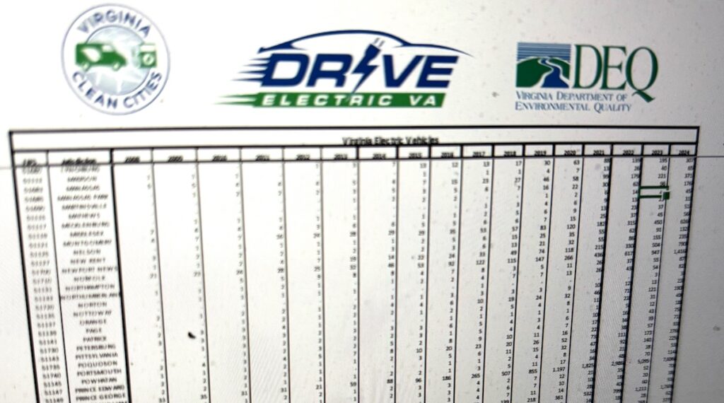
EV Data Provided in partnership with EV Atlas
Virginia Electric Vehicle Registrations by Jurisdiction (2008-2024)
Electric Vehicle Charging Reports
Statewide Electric Vehicle Charging Report
In May and June of 2021, Virginia Clean Cities developed a statewide report for Virginia and Washington D.C. to assess the Commonwealth’s Electric Vehicle Charging Infrastructure Projections and 10% Deployment Scenario. The objective of this report is to outline the tools and benefits available to the Commonwealth that will allow state and local planners to make informed decisions about initial market scale volumes and locations of electric vehicle charging.
This report includes electrification projections from the Electric Vehicles Infrastructure Projection tool to obtain and support 10% EV ownership and outlines a number of considerations and planning and mapping tools that can aid the planning process for equitable and effective charging deployments. In addition to the tools outlined, the report also demonstrates how supporting EV infrastructure will serve the Commonwealth by lessening reliance on outside oil, stimulating local economies, improving air quality, and reducing transportation financial burdens on underserved communities.
Read the full Virginia Report here.
Locality Electric Vehicle Charging Reports
Presented are 13 unique Electric Vehicle Charging Infrastructure Projections and 10% Deployment Scenario reports for major urban areas in Virginia. Localities include Bristol, Blacksburg, Charlottesville, Fredericksburg, Harrisonburg, Lynchburg, Richmond, Roanoke, Staunton/Waynesboro, Virginia Beach, Washington, DC, Williamsburg, and Winchester.
Reports include electrification projections from the Electric Vehicles Infrastructure Projection tool to obtain and support 10% EV ownership in each respective region. Additional tools for planning infrastructure are such as the Energy Zones Mapping Tool, Alternative Fuel Station Locator, and the MJ Bradley Infrastructure Planning Tool are included for equitable and effective deployment considerations.
Blacksburg-Area-EV-Charging-Report
Bristol-Area-EV-Charging-Report
Charlottesville-Area-EV-Charging-Report
Fredericksburg-Area-EV-Charging-Report
Fredericksburg Fleet Electrification Analysis Report
Fredericksburg Schools Electrification Analysis Report
Harrisonburg-Area-EV-Charging-Report
Lynchburg-Area-EV-Charging-Report
Richmond-Area-EV-Charging-Report
Roanoke-Area-EV-Charging-Report
Staunton &Waynesboro-Area-EV-Charging-Report
University of Mary Washington Electrification Analysis Report
Virginia-Beach-Area-EV-Charging-Report
Williamsburg-Area-EV-Charging-Report
Deployment Tools
Alternative Fuel Station Locator
Energy Zones Mapping Tool
An important initiative for EV deployment is to ensure it is done equitably. In order to assess how we can meet this goal, there is a public government tool called the Energy Zones Mapping Tool, produced by Argonne National Laboratory. This tool allows the application of unique overlays to be placed over the United States for visual comprehension of data of certain geographical trends. There are multiple overlays available that we can use to assess where charging stations can be installed to best serve all people.
Register for free for the full tool https://ezmt.anl.gov/
Or, try out this instant-access, Mid-Atlantic Electrification Partnership Mapping Portal– https://anl.maps.arcgis.com/
Instructions and example analysis can be found in VCC’s Statewide Electric Vehicle Charging Report
An Argonne National Laboratory tutorial can be found here –
MJ Bradley & Associates Regional EV Charging Infrastructure Location Identification Toolkit
The MJ-Bradley & Associates Tool is designed to grade census tract locations on several categories ranging from DCFC proximity, DCFC port density, traffic volume, and population density. In a most recent update, the MJ Bradley Tool now includes metrics taken from the EPA’s EJSCREEN tool for measurements on disadvantaged communities to be included in EV charger infrastructure planning.
The full tool and overview can be found here.
Dominion Energy

Dominion Energy Electric Vehicle (EV) Capacity Map Tool
This interactive tool by Dominion Energy is designed to help optimize the installation of EV fast charging stations. This tool provides information about which parts of our electric distribution system may be more suitable for EV fast charging station installations. The tool shows high voltage three-phase distribution lines and their current grid capacity availability within one mile of major interstates and highways as well as existing public fast charging stations in Virginia and North Carolina.
StreetLight Data Electric Vehicle Charging Dashboard
The dashboard shows gaps in the existing EV charging network. The location of these gaps depends on what you want to prioritize: Level 2 networks, which recharge vehicles over longer time periods; or super-fast Level 3 networks, to support long-distance travelers? Is the goal to make charging accessible for existing EV drivers, for low-income populations, or for long-haul trucking? The dashboard offers several potential goals that public agencies or private companies may want to consider.
This dashboard is powered by StreetLight Data’s proprietary movement data, coupled with additional datasets about EV ownership, demographics, and more.
